
| Russell Creek | |
| Name Etymology: | Named for Peter Russell |
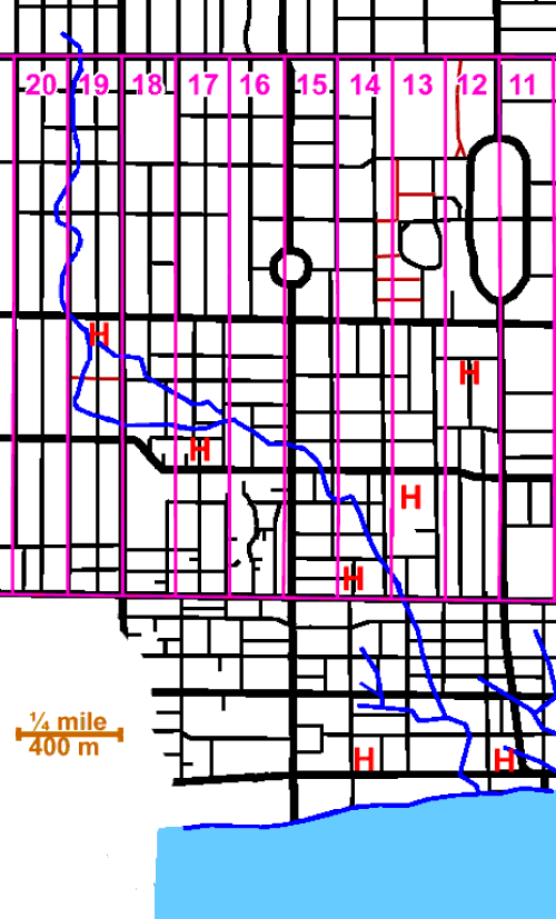
| Map: | Russell Creek, circa 1818.jpg |
| Pushpin Map: | Canada Toronto |
| Pushpin Map Caption: | Historic location of the mouth of the creek in Toronto |
| Subdivision Type1: | Country |
| Subdivision Name1: | Canada |
| Subdivision Type2: | Province |
| Subdivision Name2: | Ontario |
| Subdivision Type3: | Region |
| Subdivision Name3: | Greater Toronto Area |
| Subdivision Type5: | Municipality |
| Subdivision Name5: | Toronto |
| Length: | 3.4km (02.1miles) |
| Source1 Coordinates: | 43.665°N -79.4139°W |
| Source1 Elevation: | 115m (377feet) |
| Mouth: | Lake Ontario |
| Mouth Coordinates: | 43.6444°N -79.3847°W |
| Mouth Elevation: | 74m (243feet) |
| River System: | Great Lakes Basin |
| Tributaries Right: | Metro Creek |
Russell Creek was a short creek, 3.4km (02.1miles) long, that flowed through what is now downtown Toronto, Ontario, Canada, west of the original town of York.[1] The creek was named for Peter Russell and flowed generally southeast,[2] like all the other waterways in Toronto, reflecting the recent glaciation, into Toronto Harbour near the present CN Tower. The creek was buried in 1876, but traces of it can still be found, for instance on the grounds of the historic Grange mansion.
The Spadina Brewery was built on its banks, in 1837, and used its waters.