List of mountains in the United Arab Emirates explained
The U.A.E. is not a mountainous country, as most of its territory is desert or semi-desert and relatively flat, but it does have excellent mountains, which are part of the Hajar Mountains,[1] located in the northeast of Oman and east of the U.A.E., [2] which are the highest in the eastern part of the Arabian Peninsula.[3]
Most of the country's mountains, with altitudes higher than 1000m (3,000feet), are located in the emirate of Emirate of Ras Al Khaimah, and it is no coincidence that some of its most important summits are located exactly on the border with the Sultanate of Oman, as, in some cases, their position was taken as a reference for the drawing of the border limits between both countries.[4] [5]
A boundary agreement was signed and ratified in 2003 for the entire border between the United Arab Emirates and Oman, including Oman's Musandam Peninsula and Al Madhah enclaves, but the contents of the agreement, and detailed maps showing the alignment, have not been published, [6] although border stones have been placed. The future publication of these agreements and maps could make it necessary to modify the content of this article.
This list includes the name and location of the summits located entirely within the territory of the United Arab Emirates, or at least with its summit located on the border line, regardless of its height. The list is open to new additions referring to mountains that meet these conditions, with a known name and position, and whose reference data is supported by historical maps or other reliable documentary sources.
Many of these mountains are known by different names, the result of local tradition and of the various transcriptions from Arabic to English, so that an individual reference note includes the alternative names with which the mountain has been identified at some point, accompanied by their respective documentary sources.
The region is represented in different satellite images, mainly Google Earth, Google Satellite and Bing Satellite. The exact coordinates of each summit and its altitude, with respect to sea level, have been established by comparing the OpenTopoMap and OpenMapTiles topographic maps with these images, treating each with the greatest objectivity and the same measurement criteria for all the summits. In some cases, direct recognition and location by GPS have also been used, or references have been checked against data provided by hikers and climbers in itineraries published online.
In this article, the values of prominence were not taken into account, nor the topographic isolation, to give priority to identifying the mountains and location of their summits.
List of mountains
Mountains of United Arab Emirates ! width=150px | Name | width=60px | Notes and citations | Order | width=150px | Mountain range | width=150px | Country | width=150px | Emirate / Governorate | width=70px | Altitude (m) | Coordinates |
|---|
| bgcolor=#D8D8D8 | Jabal as Sayh | [7] | 001 | |
| | | 25.9719°N 56.1917°W |
| bgcolor=#D8D8D8 | Jabal Hadaba | [8] [9] | 002 | |
|
Musandam | | 26.019°N 56.1823°W |
| bgcolor=#D8D8D8 | | [10] [11] [12] | 003 | | | | | 25.9442°N 56.1522°W |
| bgcolor=#D8D8D8 | Jabal Sal | [13] | 004 | | | | | 25.9325°N 56.1692°W |
| bgcolor=#D8D8D8 | Jabal Harf Tila | [14] [15] [16] [17] | 005 | |
|
Musandam | | 25.6893°N 56.1585°W |
| bgcolor=#D8D8D8 | | [18] [19] [20] | 006 | | | | | 25.9258°N 56.1167°W |
| bgcolor=#D8D8D8 | | [21] [22] [23]
[24] [25] [26] | 007 | | | | | 25.6486°N 56.1286°W |
| bgcolor=#D8D8D8 | Jabal Yabana | [27] | 008 | |
| | | |
| bgcolor=#D8D8D8 | Jabal Shintal | [28] | 009 | | | | | |
| bgcolor=#D8D8D8 | Jabal Harf | [29] | 010 | | | | | |
| bgcolor=#D8D8D8 | | [30]
[31] | 011 | | | | | |
| bgcolor=#D8D8D8 | Um Alnosoor / Jabal Hatta | [32] [33]
[34] [35] [36] | 012 | |
| | | |
| bgcolor=#D8D8D8 | Jabal Khabb | | 013 | | | | | |
| bgcolor=#D8D8D8 | Jabal Masafi | [37] [38] [39] [40] | 014 | | |
| | |
| bgcolor=#D8D8D8 | | [41] [42]
[43] [44] [45] | 015 | |
| | | |
| bgcolor=#D8D8D8 | Jabal Ghabbas | [46] | 016 | |
| | | |
| bgcolor=#D8D8D8 | Jabal Hilqah | | 017 | | | | align=right | | |
| bgcolor=#D8D8D8 | Jabal Dad |
[47] | 018 | | | | align=right | | |
| bgcolor=#D8D8D8 | Jabal Hudayd | [48] | 019 | | | | | |
| bgcolor=#D8D8D8 | Jabal Al Itim | | 020 | | | | | |
| bgcolor=#D8D8D8 | Jabal Ayuzah | | 021 | | | | | |
| bgcolor=#D8D8D8 | Jabal Qitab | [49] | 022 | | | | | |
| bgcolor=#D8D8D8 | Jabal Qandus | | 023 | | | | | |
| bgcolor=#D8D8D8 | Jabal Ash Shu | | 024 | | | | | |
| bgcolor=#D8D8D8 | Jabal Samah | [50] | 025 | | | | | |
| bgcolor=#D8D8D8 | Jabal Bu Faraj | [51] [52] | 026 | |
| | | |
| bgcolor=#D8D8D8 | Jabal Naqat | | 027 | | | | | |
| bgcolor=#D8D8D8 | Jabal Huwarah | | 028 | | | | | |
| bgcolor=#D8D8D8 | Jabal Najdayn | [53] | 029 | | | | | |
| bgcolor=#D8D8D8 | Jabal Yabsah | [54] | 030 | | | | | |
| bgcolor=#D8D8D8 | Jabal Ar Ra'alah | | 031 | | | | | |
| bgcolor=#D8D8D8 | Jabal Bulaydah | [55] | 032 | | | | | |
| bgcolor=#D8D8D8 | Jabal Wamm | [56] | 033 | | | | | |
| bgcolor=#D8D8D8 | Jabal Mimduk | [57] | 034 | | | | | |
| bgcolor=#D8D8D8 | Jabal Al Himri | | 035 | | | | | |
| bgcolor=#D8D8D8 | Jabal Saddariyyah | | 036 | |
| | | |
| bgcolor=#D8D8D8 | Jabal Sall | [58] [59] | 037 | | | | | |
| bgcolor=#D8D8D8 | Jabal Siha | [60] | 038 | | | Sharjah | | |
| bgcolor=#D8D8D8 | Jabal Rams | [61] | 039 | | | | | |
| bgcolor=#D8D8D8 | Jabal Qutayyib | [62] | 040 | | | | | | |
See also
External links
Notes and References
- Book: Cavendish . Marshall . Marshall Cavendish . World and Its Peoples . 1 . Geography and climate . 2007 . Cavendish Square Publishing . 978-0-7614-7571-2 . 8–19 . https://books.google.com/books?id=j894miuOqc4C&pg=PA8 . limited .
- Book: National Geographic . Atlas of the Middle East- National Geographic Society (U.S.). Book Division, National Geographic Society (U.S.)· 2008 . 2008 . 9781426202216 . 2023-05-15.
- Web site: www.britannica.com. United Arab Emirates - Relief . 2023-05-08.
- Web site: Arabian Gulf Digital Archives . FO 371/132797 - Frontiers between Muscat and Trucial States- 1958 - The National Archives, London, England . 2023-05-13.
- Web site: www.countrystudies.us. United Arab Emirates - Geography - Country Studies . 2023-05-15.
- Web site: CIA.gov . The World Factbook . 2023-05-08.
- Web site: Mindat.org . Mindat - Jabal as Sayḩ . 2023-05-08.
- FCO 18/1920 - 1962 - Boundaries of the Northern Trucial States: prepared and drawn from sketch maps and information supplied by Julian Walker; preliminary edition
- FCO 18/1932 - 1958 - Sketch map drawn by Julian Walker for boundary delimitation: Ras Al Khaimah
- Web site: Mindat.org . Mindat - Jabal ar Raḩraḩ . 2023-05-08.
- Web site: Arabian Gulf Digital Archives . FCO 18/1863 - Map of Trucial States, Muscat and Oman - Rams - Scale 1:100 000 - Published by D Survey, Ministry of Defence, United Kingdom (1971) - Edition 3-GSGS - The National Archives, London, England . 2023-05-08.
- Jāmiʻat al-Imārāt al-ʻArabīyah al-Muttaḥidah. Geoprojects (U.K.) Ltd., The National atlas of the United Arab Emirates, Al Ain : United Arab Emirates University - 1993
- Web site: Mindat.org . Mindat - Jabal Sāl . 2023-05-08.
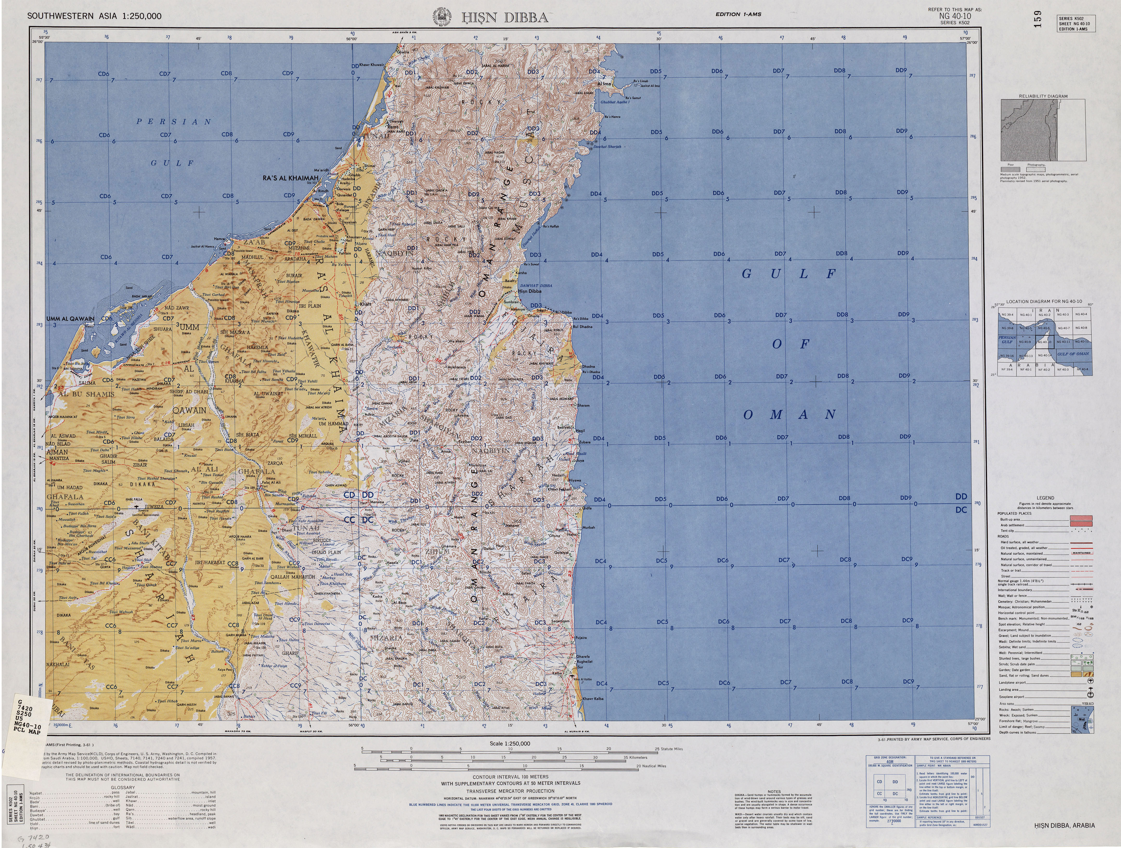
- Web site: maps.lib.utexas.edu . Hisn Dibba Map . 2022-12-22.
- Web site: Arabian Gulf Digital Archives . Water supply - Ref. FO 371/163058 - 1962 - The National Archives, London, England . 2024-06-09.
- Web site: Wikiloc - Trails of the World. Wadi Naqab, Bristly Ridge, Jebel Harf Tila and the Villages . 2023-05-08.
- Web site: Wikiloc - Trails of the World . Wadi Taween to Wadi Naqab via Jebel Harf Tila . 2023-05-08.
- Tribulus - Volume 19 - 2011 - Journal of the Emirates Natural History Group - The Flora of the Ru'us al-Jibal -the Mountains of the Musandam Peninsula: An Annotated Checklist and Selected Observations - Gary R. Feulner - Abu Dhabi, United Arab Emirates, 2011
- Web site: Mindat.org . Mindat - Jabal Rahabah . 2023-05-08.
- Web site: Arabian Gulf Digital Archives . FCO 18/1897 Map Boundaries of the Northern Trucial States (1963) - The National Archives, London, England . 2023-05-08.
- Web site: Arabian Gulf Digital Archives . FCO 18/1791 - Map of Trucial States, Muscat and Oman - Dibba - Scale 1:100 000 - Published by D Survey, Ministry of Defence, United Kingdom (1971) - Edition 3-GSGS - The National Archives, London, England . 2023-05-08.
- Web site: Peakbagger.com . Jabal Yibir, United Arab Emirates . 2024-03-02.
- Web site: Arabian Gulf Digital Archives . FO 1016/840 - 1965 Jan 01 - 1965 Dec 31 - Map Trucial States: water resources; with hydrological and groundwater survey - The National Archives, London, England . 2023-05-12.
- Web site: Arabian Gulf Digital Archives . FO 371/163060 - Oil - Map Persian Gulf. Ras Jask to Jazirat Sirri - Oil concessions in the Trucial States - 1962 - The National Archives, London, England . 2024-04-24.
- News: Watch: UAE: Authorities airlift elderly Emirati who fell off mountain. Jabal Mebrah Mountain . www.khaleejtimes.com. en-US. 2023-05-13.
- Web site: U.S. Central Intelligence Agency . Map United Arab Emirates (Shaded Relief) 1995 . 2024-07-08.
- Web site: Mindat.org . Mindat - Jabal Yabānah . 2023-05-08.
- Web site: Arabian Gulf Digital Archives . FCO 18/1966 - Sketch map drawn by Julian Walker for boundary delimitation: Ras Al Khaimah - The National Archives, London, England . 2023-05-08.
- FCO 18/1969 - 1959 - Sketch map drawn by Julian Walker for boundary delimitation: Dibba - The National Archives, London, England
- Web site: Mindat.org . Mindat - Jabal Qada'ah . 2023-05-08.
- Web site: Wikiloc - Trails of the World. Jebel Qada'ah - Routes 2 and 3 . 2023-05-11.
- Web site: GeoNames.org . GeoNames - Um Alnosoor . 2023-05-08.
- Web site: Arabian Gulf Digital Archives . FCO 18/1796 - Map of Trucial States, Muscat and Oman - Aswad - Scale 1:100 000 - Published by D Survey, Ministry of Defence, United Kingdom (1971) - Edition 3-GSGS - The National Archives, London, England . 2023-05-08.
- Web site: Arabian Gulf Digital Archives . FCO 18/1898 Map Boundaries of the Northern Trucial States (1963) - The National Archives, London, England . 2023-05-08.
- Web site: Wikiloc - Trails of the World. Um Alnosoor trail . 2023-05-12.
- News: Sheikh Mohammed bin Rashid unveils six new tourism projects planned for Hatta. Attractions will centre around Jabal Umm Al Nusour, Dubai's highest peak . www.thenationalnews.com. en-US. 2023-05-13.
- Web site: Arabian Gulf Digital Archives . FCO 18/1792 - Map of Trucial States, Muscat and Oman - Masafi - Scale 1:100 000 - Published by D Survey, Ministry of Defence, United Kingdom (1972) - Edition 3-GSGS - The National Archives, London, England . 2023-05-08.
- Tribulus - Volume 22 - 2014 - Journal of the Emirates Natural History Group - The Olive Highlands: A unique "island" of biodiversity within the Hajar Mountains of the United Arab Emirates - Gary R. Feulner - Abu Dhabi, United Arab Emirates, 2014
- Web site: Mindat.org . Mindat - Jabal Masafi . 2023-05-08.
- Web site: Wikiloc - Trails of the World. Jebel Masafi (or thereabouts) . 2023-05-08.
- Web site: Mindat.org . Mindat - Jabal Ḩafīt . 2023-05-08.
- Web site: Peakbagger.com . Jebel Hafeet, United Arab Emirates . 2023-05-09.
- Web site: Arabian Gulf Digital Archives . FO 371/168946 - 1966 - Map of ADPC's gravity surveys in southern Abu Dhabi - Oil - The National Archives, London, England . 2023-05-12.
- News: An adventure across Abu Dhabi's diverse landscapes. Jebel Hafit mountain, which at around 3,800 feet is one of the UAE's highest peaks . https://web.archive.org/web/20230109110129/https://www.nationalgeographic.com/travel/article/paid-content-an-adventure-across-abu-dhabis-diverse-landscapes. dead. January 9, 2023. www.nationalgeographic.com. en-US. 2023-05-13.
- News: Injured Emirati hiker rescued from Jebel Hafeet . www.thenationalnews.com. en-US. 2023-05-13.
- Web site: Mindat.org . Mindat - Jabal Ghabbas, Umm al Qaywayn, United Arab Emirates . 2024-06-11.
- Web site: Mindat.org . Mindat - Jabal Dād . 2023-05-08.
- Web site: Mindat.org . Mindat - Jabal Hudayd . 2023-05-08.
- Web site: Mindat.org . Mindat - Jabal Qitab . 2023-05-08.
- Web site: Mindat.org . Mindat - Jabal Samah . 2023-05-08.
- Web site: Arabian Gulf Digital Archives . FO 371/140224 - 1959 - Relations between rulers of Trucial States and Petroleum Development Trucial Coast Company. Code BA file 1531 (papers 12 to end) - The National Archives, London, England . 2024-05-31.
- Web site: Mindat.org . Mindat - Jabal Bu Faraj . 2023-05-13.
- Web site: Mindat.org . Mindat - Jabal Najdayn, Ra’s al Khaymah, United Arab Emirates . 2024-07-26.
- Web site: Mindat.org . Mindat - Jabal Jabsah, Al Fujayrah, United Arab Emirates . 2024-08-18.
- Web site: Mindat.org . Mindat - Jabal Bulaydah . 2023-05-08.
- Web site: Mindat.org . Mindat - Jabal Wamm, Al Fujayrah, United Arab Emirates . 2024-06-27.
- Web site: Mindat.org . Mindat - Jabal Mimdūk, Al Fujayrah, United Arab Emirates . 2024-06-11.
- FCO 18/1969 - 1959 - Sketch map drawn by Julian Walker for boundary delimitation: Dibba - The National Archives, London, England
- Web site: Mindat.org . Mindat - Jabal Sall, Ra’s al Khaymah, United Arab Emirates . 2023-06-11.
- Web site: Geoview.info . Geoview - Jabal Şihā’ . 2023-06-20.
- Web site: Mindat.org . Mindat - Jabal Rams . 2023-05-08.
- Web site: Mindat.org . Mindat - Jabal Qutayyib . 2023-05-08.
