
The Metropolitan Transportation Authority (MTA) operates 80 express bus routes in New York City, United States. Express routes operated by MTA Bus Company are assigned multi-borough (BM, BxM, QM) prefixes. MTA New York City Bus operates seven of the express routes in Brooklyn and Queens, which are prefixed with the letter X, as well as all express routes in Staten Island, which are prefixed with the letters SIM.
The unidirectional fare, payable with MetroCard or OMNY, a contactless payment system, is $7. Discount fare media is available. Except for the ad hoc X80 service, coins are not accepted on express buses.
Express buses operate using over-the-road diesel-powered, 45-ft-long coaches, from Motor Coach Industries and Prevost Car. For more information, visit the fleet page.
Most routes travel to and from Staten Island via the Verrazzano-Narrows Bridge, Gowanus Expressway, and Hugh L. Carey Tunnel into Lower Manhattan. Some routes operate through New Jersey via the Goethals Bridge, New Jersey Turnpike, New Jersey Route 495, and Lincoln Tunnel to directly serve Midtown Manhattan.
On August 19, 2018, all of the Staten Island-Manhattan express bus routes were redesigned to offer simpler and direct routes, fewer stops to speed up the trips, and additional service for off-peak hours and weekends. The new routes originally planned consists of 21 express routes: 11 traveling to Midtown, 8 traveling to Downtown and 2 traveling to Greenwich Village via Battery Park City. The previously used "X" routes have been dropped in favor of "SIM," or Staten Island to Manhattan, routes. This was the result of the two-year Staten Island Bus Study conducted by MTA, launched in 2015, which analyzed trip performance data, ridership profiles and extensive customer input, to determine the most effective way to reconfigure the network.[1] [2]
All routes are operated by New York City Transit. All routes run during rush hours in the peak direction. In addition, the SIM1C, SIM3C, SIM4C and SIM33C provide off-peak weekday and weekend service, and the SIM1C provides overnight service. These four -C routes cover most stops in Manhattan served by other routes during peak hours.
| Route | Manhattan terminal | Staten Island terminal | Manhattan streets | width=5% | Via | Staten Island streets traveled | |
|---|---|---|---|---|---|---|---|
[3] [4] | Greenwich Village Sixth Avenue and Houston Street (last drop-off) Broadway and Houston Street (first pick-up) | ← AM → PM | Eltingville Transit Center |
| Verrazzano-Narrows Bridge, Gowanus Expressway and Hugh L. Carey Tunnel | Hylan Boulevard, Richmond Avenue | |
| Midtown Central Park South and Sixth Avenue | ↔ |
| |||||
[6] [7] | Downtown Church Street and Worth Street (last drop-off) Broadway and Warren Street (first pick-up) | ← AM → PM | Tottenville Craig Avenue and Hylan Boulevard |
| Arden Avenue, Woodrow Road, Huguenot Avenue, Hylan Boulevard | ||
[8] | Midtown Central Park South and Sixth Avenue | Port Richmond Castleton Avenue and Jewett Avenue |
|
| |||
| ↔ |
| ||||||
[9] | Downtown Church Street and Worth Street (last drop-off) Broadway and Chambers Street (first pick-up) | ← AM → PM | Annadale Annadale Road and Drumgoole Road West |
| Richmond Avenue | ||
| Staten Island Mall Park and Ride | |||||||
| Midtown Sixth Avenue and 59th Street | ↔ | Huguenot Boulder Avenue and Woodrow Road (last drop-off) Vineland Avenue and Woodrow Road (first pick-up) |
| ||||
[10] | Downtown Pearl Street and Peck Slip (last drop-off) Pearl Street and Frankfort Street (first pick-up) | ← AM → PM | Eltingville Transit Center | Water Street | Father Capodanno Boulevard, Hylan Boulevard, Nelson Avenue | ||
[11] | Midtown Lexington Avenue and 57th Street (last drop-off) Lexington Avenue and 56th Street (first pick-up) |
| |||||
[12] | Greenwich Village Sixth Avenue and 14th Street (last drop-off) Broadway and 13th Street (first pick-up) |
| Narrows Road, Hylan Boulevard, Richmond Avenue | ||||
[13] | Midtown 57th Street and Lexington Avenue | Huguenot Woodrow Road and Huguenot Avenue |
| Goethals Bridge, NJ Turnpike, and Lincoln Tunnel |
| ||
| Staten Island Mall Staten Island Mall Park and Ride | |||||||
[14] | Greenwich Village Sixth Avenue and 14th Street (last drop-off) Broadway and 13th Street (first pick-up) | Eltingville Hylan Boulevard and Richmond Avenue |
| Verrazzano-Narrows Bridge, Gowanus Expressway and Hugh L. Carey Tunnel | Father Capodanno Boulevard, Hylan Boulevard | ||
| Midtown Central Park South and Sixth Avenue | Eltingville Transit Center |
| Narrows Road, Hylan Boulevard, Richmond Avenue | ||||
| Midtown Lexington Avenue and 57th Street (last drop-off) Lexington Avenue and 56th Street (first pick-up) | New Dorp Ebbitts Street and Mill Road |
| Narrows Road, Hylan Boulevard | ||||
| Downtown Water Street and Hanover Square (last drop-off) Trinity Place and Rector Street (first pick-up) | Eltingville Transit Center | Church Street, Water Street | Narrows Road, Richmond Road, Arthur Kill Road | ||||
| Midtown 57th Street and Lexington Avenue | Eltingville Woods of Arden Road and Hylan Boulevard |
| Goethals Bridge, NJ Turnpike, and Lincoln Tunnel | Arthur Kill Road, Richmond Avenue | |||
[15] | Midtown Madison Avenue and 59th Street (last drop-off) Fifth Avenue and 59th Street (first pick-up) | Annadale Poillion Avenue and Hylan Boulevard |
| Arden Avenue | |||
[16] | Huguenot Hylan Boulevard and Luten Avenue | Hylan Boulevard | |||||
| Midtown 57th Street and Lexington Avenue | Tottenville Craig Avenue and Hylan Boulevard |
| Rossville Avenue, Foster Road, Hylan Boulevard | ||||
| Tottenville Page Avenue and Hylan Boulevard (last drop-off) Bedell Avenue and Hylan Boulevard (first pick-up) |
| Bloomingdale Road, Amboy Road, Hylan Boulevard | |||||
| Midtown Sixth Avenue and 59th Street | Sunnyside Clove Road and Victory Boulevard |
|
| ||||
| Rosebank Tompkins Avenue and Hylan Boulevard | |||||||
| Midtown 57th Street and Lexington Avenue | Eltingville Transit Center |
| Verrazzano-Narrows Bridge, Gowanus Expressway and Hugh L. Carey Tunnel | Gannon Avenue, Bradley Avenue, Harold Street, Forest Hill Road, Travis Avenue | |||
| Downtown Church Street and Worth Street (last drop-off) Broadway and Warren Street (first pick-up) | Travis Victory Boulevard bus loop |
| Gannon Avenue, Victory Boulevard | ||||
| Downtown Sixth Avenue and 14th Street (last drop-off) Broadway and 13th Street (first pick-up) | Mariners Harbor South Avenue and Richmond Terrace |
|
| ||||
| Midtown Central Park South and Sixth Avenue | ↔ |
| |||||
| Downtown Sixth Avenue and Houston Street (last drop-off) Broadway and Houston Street (first pick-up) | ← AM → PM |
| Victory Boulevard, Watchogue Road, Richmond Avenue, Forest Avenue, South Avenue | ||||
| Downtown Pearl Street and Peck Slip (last drop-off) Pearl Street and Frankfort Street (first pick-up) | Port Richmond Castleton Avenue and Jewett Avenue | Water Street | Narrows Road, Clove Road, Forest Avenue, Port Richmond Avenue |
| Route | Original route(s) | History | |
|---|---|---|---|
| SIM1 SIM1C | X1, X3, X4 |
| |
| SIM2 | X17C, X19 |
| |
| SIM3 SIM3C | X10, X12, X14, X42 |
| |
| SIM4 SIM4X SIM4C | X17A, X17C |
| |
| SIM5 | X4, X7, X8 | ||
| SIM6 | X5, X7 |
| |
| SIM7 | X1, X3, X4, X7, X9 | ||
| SIM8 SIM8X | X17J, X23 |
| |
| SIM9 | X1, X3, X4, X7, X9 |
| |
| SIM10 | X1, X2, X5, X7, X9 | ||
| SIM11 | X2 |
| |
| SIM15 | X15 | ||
| SIM22 | X1, X5, X17J, X21, X23 |
| |
| SIM23 SIM24 | X17J, X23, X24 |
| |
| SIM25 | X22, X23 |
| |
| SIM26 | X17, X22 |
| |
| SIM30 | X12, X14, X30, X42 | ||
| SIM31 | X10, X31 | ||
| SIM32 | X10, X11 | ||
| SIM33 | X10, X12 | ||
| SIM33C | X10, X12 |
| |
| SIM34 | X12 | ||
| SIM35 | X10, X14 |
X- routes are operated by New York City Transit, while BM-routes are operated by MTA Bus Company. All routes operate nonstop between Brooklyn and Manhattan via the Gowanus Expressway or Prospect Expressway to the Hugh L. Carey Tunnel, with some routes continuing non-stop via the FDR Drive to reach Midtown. The exception to this is the BM5, which also makes stops in Queens and uses Woodhaven Boulevard, the Long Island Expressway and Queens Midtown Tunnel to reach Midtown.
| Route | Manhattan terminal | Brooklyn terminal | Manhattan streets traveled | width=5% | Via | Brooklyn streets traveled | |
|---|---|---|---|---|---|---|---|
X27 |
| ↔ | Bay Ridge Shore Road and 4th Avenue |
| Gowanus Expressway, Hugh L. Carey Tunnel | 3rd Avenue, Bay Ridge Avenue, Shore Road | |
X28 | Bensonhurst Cropsey Avenue and Canal Avenue | 86th Street, 14th Avenue, Cropsey Avenue, Surf Avenue | |||||
| Sea Gate West 37th Street and Surf Avenue | |||||||
X37 | Midtown East 57th Street and Madison Avenue | ← AM → PM | Bay Ridge Shore Road and 4th Avenue |
| 3rd Avenue, Bay Ridge Avenue, Shore Road | ||
X38 | Bensonhurst Cropsey Avenue and Canal Avenue | 86th Street, 14th Avenue, Cropsey Avenue, Surf Avenue | |||||
| Sea Gate West 37th Street and Surf Avenue | |||||||
BM1 | Midtown East 57th Street and 2nd Avenue | ↔ | Mill Basin 56th Drive and Strickland Avenue |
| Prospect Expressway, Hugh L. Carey Tunnel | Ocean Avenue, Avenue K | |
| Downtown State Street and Battery Place | ← AM → PM | ||||||
BM2 | Midtown East 57th Street and 2nd Avenue | ↔ | Canarsie Flatlands Avenue and Williams Avenue |
| |||
| Downtown State Street and Battery Place | ← AM → PM | Starrett City Pennsylvania Avenue and Seaview Avenue | |||||
BM3 | Midtown East 57th Street and 2nd Avenue | ↔ | Sheepshead Bay Emmons Avenue and Shore Boulevard | Coney Island Avenue, Ocean Avenue, Emmons Avenue | |||
| Downtown State Street and Battery Place | ← AM → PM | ||||||
BM4 | Midtown East 57th Street and 2nd Avenue | ↔ | Gerritsen Beach Gerritsen Avenue and Lois Avenue | Coney Island Avenue, Nostrand Avenue, Gerritsen Avenue | |||
| Downtown State Street and Battery Place | ← AM → PM | ||||||
BM5 | Midtown East 57th Street and 2nd Avenue | ↔ | Starrett City Pennsylvania Avenue and Seaview Avenue |
| Long Island Expressway, Queens Midtown Tunnel | Woodhaven Boulevard, Linden Boulevard, Pennsylvania Avenue | |
| Route | History |
|---|---|
| X27 |
|
| X28 |
|
| X37 X38 |
|
| BM1 BM2 BM3 BM4 |
|
| BM5 |
|
The MTA released a draft plan for Brooklyn's bus network redesign on December 1, 2022.[37] [38] The new plan retains the "BM" prefix and preserves all existing routes. The BM1, BM2, BM3, BM4, X27/X37, and X28/X38 will each be split into three routes: a rush-hour downtown route, a rush-hour midtown route, and an off-peak downtown and midtown route. In general, the revised plan includes the following changes:[39]
| Route | Manhattan terminal | Brooklyn terminal | Manhattan streets traveled | width=5% | Via | Brooklyn streets traveled | Notes | |
|---|---|---|---|---|---|---|---|---|
BM1 | Downtown State Street and Battery Place | ← AM → PM | Mill Basin 56th Drive and Strickland Avenue | Water Street | Prospect Expressway, Hugh L. Carey Tunnel | Beverley Road, Ocean Avenue, Avenue J, Avenue K |
| |
BM1C | Midtown East 57th Street and 2nd Avenue | ⇆ |
| |||||
BM2 | Downtown State Street and Battery Place | ← AM → PM | Starrett City Pennsylvania Avenue and Seaview Avenue | Water Street | Prospect Expressway, Hugh L. Carey Tunnel |
| ||
BM2C | Midtown East 57th Street and 2nd Avenue | ⇆ | Starrett City Fountain Avenue and Williams Avenue |
| ||||
BM3 | Downtown State Street and Battery Place | ← AM → PM | Sheepshead Bay Emmons Avenue and Shore Boulevard | Water Street | Prospect Expressway, Hugh L. Carey Tunnel | Ocean Avenue, Avenue X, Batchelder Street, Emmons Avenue |
| |
BM3C | Midtown East 57th Street and 2nd Avenue | ⇆ |
| |||||
BM4 | Downtown State Street and Battery Place | ← AM → PM | Gerritsen Beach Gerritsen Avenue | Water Street | Prospect Expressway, Hugh L. Carey Tunnel | Coney Island Avenue, Avenue L, Nostrand Avenue, Gerritsen Avenue |
| |
BM4C | Midtown East 57th Street and 2nd Avenue | ⇆ |
| |||||
BM7 | Downtown Thomas Street and Church Street | ↔ | Bay Ridge Shore Road and 4th Avenue |
| Gowanus Expressway, Hugh L. Carey Tunnel | 3rd Avenue, Bay Ridge Avenue, Shore Road |
| |
BM7C | Midtown East 57th Street and 2nd Avenue | ↔ |
| Service between Duane/Thomas Streets and 23rd Street provided during off-peak hours only. | ||||
BM8 | Downtown Thomas Street and Church Street | ↔ | Bensonhurst Cropsey Avenue and Canal Avenue |
| Gowanus Expressway, Hugh L. Carey Tunnel | 86th Street, 14th Avenue, Cropsey Avenue |
| |
BM8C | Midtown East 57th Street and 2nd Avenue | ↔ |
| Service between Duane/Thomas Streets and 23rd Street provided during off-peak hours only. | ||||
BM31 | Midtown East 57th Street and 2nd Avenue | ↔ | Mill Basin 56th Drive and Strickland Avenue |
| Prospect Expressway, Hugh L. Carey Tunnel | Beverley Road, Ocean Avenue, Avenue J, Avenue K |
| |
BM32 | Midtown East 57th Street and 2nd Avenue | ↔ | Canarsie Flatlands Avenue and Williams Avenue |
| Prospect Expressway, Hugh L. Carey Tunnel | Flatbush Avenue, Avenue H, Avenue M | Between Ocean and Coney Island Avenues in Brooklyn, the BM2/BM2C/BM32 would use Beverley Road instead of Cortelyou Road. | |
BM33 | Midtown East 57th Street and 2nd Avenue | ↔ | Sheepshead Bay Emmons Avenue and Shore Boulevard |
| Prospect Expressway, Hugh L. Carey Tunnel | Ocean Avenue, Avenue X, Batchelder Street, Emmons Avenue |
| |
BM34 | Midtown East 57th Street and 2nd Avenue | ↔ | Gerritsen Beach Gerritsen Avenue and Lois Avenue |
| Prospect Expressway, Hugh L. Carey Tunnel | Coney Island Avenue, Avenue L, Nostrand Avenue, Gerritsen Avenue | In central Brooklyn, the BM4/BM4C/BM34 would be rerouted to Coney Island Avenue and Avenue L to provide new service to Midwood and reduce the number of turns. | |
BM35 | Midtown East 57th Street and 2nd Avenue | ↔ | Starrett City Pennsylvania Avenue and Seaview Avenue |
| Long Island Expressway, Queens Midtown Tunnel | Woodhaven Boulevard, Linden Boulevard, Pennsylvania Avenue |
| |
BM37 | Midtown East 57th Street and Madison Avenue | ← AM → PM | Bay Ridge Shore Road and 4th Avenue |
| Gowanus Expressway, Hugh L. Carey Tunnel | 3rd Avenue, Bay Ridge Avenue, Shore Road |
| |
BM38 | Midtown East 57th Street and Madison Avenue | ← AM → PM | Bensonhurst Cropsey Avenue and Canal Avenue |
| Gowanus Expressway, Hugh L. Carey Tunnel | 86th Street, 14th Avenue, Cropsey Avenue |
|
X- routes are operated by New York City Transit, while QM- routes are operated by MTA Bus Company. All Midtown routes except for the Super Expresses operate nonstop outbound via the Ed Koch Queensboro Bridge, while Downtown routes operate via the FDR Drive and the Queens Midtown Tunnel. All inbound service operates via the Long Island Expressway and Queens Midtown Tunnel.
| Route | Manhattan terminal | Queens terminal | Manhattan streets traveled | Queens streets traveled | |
|---|---|---|---|---|---|
X63 | East Midtown East 23rd Street and 1st Avenue | ← AM → PM | Rosedale 149th Avenue and 253rd Street |
| Linden Boulevard, Merrick Boulevard, Francis Lewis Boulevard |
X64 | Cambria Heights Linden Boulevard and 235th Street | Liberty Avenue, Farmers Boulevard, Linden Boulevard | |||
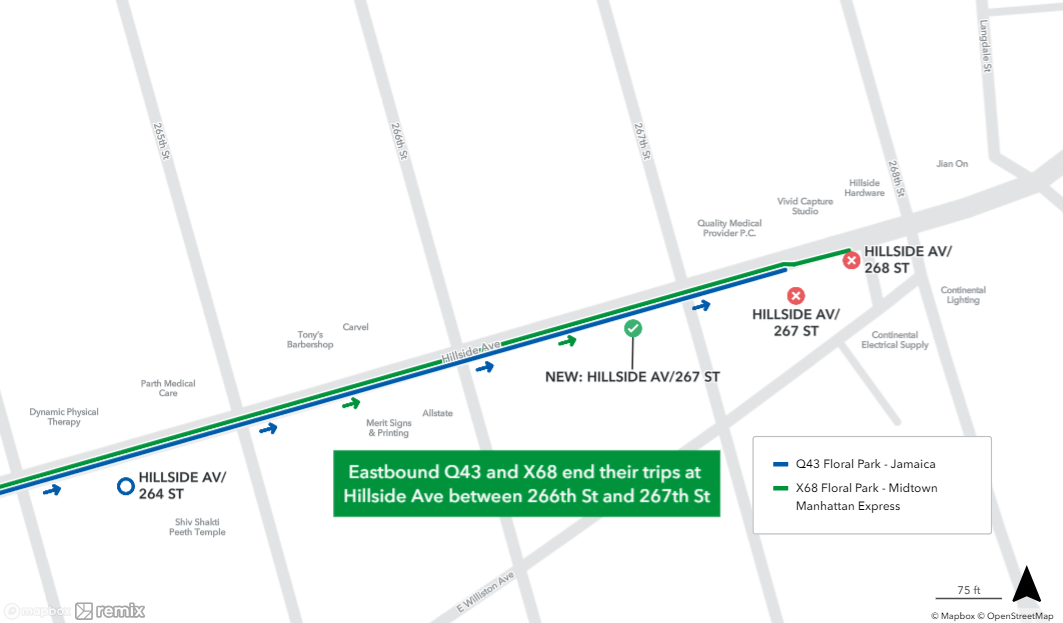
X68 | Floral Park Hillside Avenue and 267th Street | Hillside Avenue | |||
| East Midtown East 57th Street and 3rd Avenue | |||||
| Midtown 57th Street and Third Avenue (last drop-off) 36th Street and Sixth Avenue (first pick-up) | Fresh Meadows 188th Street and 64th Avenue | 34th Street, Sixth Avenue, 57th Street | Union Turnpike, 188th Street | ||
QM2 | ↔ | Bay Terrace Bay Terrace Shopping Center |
|
| |
QM2 Super Express | Midtown 35th Street and Sixth Avenue | → PM | 34th Street, Sixth Avenue, 36th Street | ||
QM3 | Midtown 57th Street and Third Avenue (last drop-off) 36th Street and Sixth Avenue (first pick-up) | ← AM → PM | Little Neck Little Neck Parkway and Horace Harding Expressway | Northern Boulevard, Little Neck Parkway | |
| ↔ | Electchester 164th Street and Horace Harding Expressway | 34th Street, Sixth Avenue, 57th Street | Jewel Avenue | ||
| Glen Oaks 260th Street and Union Turnpike | Union Turnpike, 73rd Avenue, Horace Harding Expressway | ||||
| Midtown 35th Street and Sixth Avenue | → PM | 34th Street, Sixth Avenue, 36th Street | |||
| Midtown 57th Street and Third Avenue (last drop-off) 36th Street and Sixth Avenue (first pick-up) | ↔ | Lake Success North Shore Towers | 34th Street, Sixth Avenue, 57th Street |
| |
| Downtown Frankfort Street and Pearl Street (last drop-off) Pearl Street and Peck Slip (first pick-up) | ← AM → PM | Fresh Meadows 188th Street and 64th Avenue | Water Street, Church Street |
| |
| Glen Oaks 260th Street and Union Turnpike | |||||
| Downtown Water St at Wall St | Water St, South St (outbound) Pearl St, Water St, Church St, Park Row (inbound) | ||||
QM10 | Midtown 57th Street and Sixth Avenue (last drop-off) 34th Street and Third Avenue (first pick-up) | Rego Park 57th Avenue and Junction Boulevard (last drop-off) 63rd Road and 98th Place (first pick-up, QM10) Queens Boulevard and Ascan Avenue (first pick-up, QM11) | 34th Street, Sixth Avenue, 57th Street | 63rd Road, 57th Avenue | |
QM11 | Downtown Frankfort Street and Pearl Street (last drop-off) Pearl Street and Peck Slip (first pick-up) | Water Street, Church Street | Queens Boulevard, 63rd Road, 57th Avenue | ||
QM12 | Midtown 57th Street and Sixth Avenue (last drop-off) 34th Street and Third Avenue (first pick-up) | Forest Hills Crescent Apartments (last drop-off) Metropolitan Avenue and 71st Road (first pick-up) | 34th Street, Sixth Avenue, 57th Street | Yellowstone Boulevard | |
QM15 | ↔ | Howard Beach 157th Avenue and 102nd Street | Woodhaven Boulevard, 155th Avenue, 157th Avenue, Cross Bay Boulevard | ||
QM16 | ← AM → PM | Jacob Riis Park | Cross Bay Boulevard, Rockaway Beach Boulevard | ||
QM17 | Far Rockaway Beach 21st Street and Mott Avenue at Far Rockaway-Mott Avenue | Cross Bay Boulevard, Beach Channel Drive, Seagirt Boulevard | |||
QM18 | South Ozone Park 130th Street and 150th Avenue | Queens Boulevard, Lefferts Boulevard, 135th Avenue | |||
QM20 | Midtown 57th Street and Third Avenue (last drop-off) 36th Street and Sixth Avenue (first pick-up) | ↔ | Bay Terrace 211th Street and 18th Avenue (last drop-off) Corporal Kennedy Street and 23rd Avenue (first pick-up) |
| Willets Point Boulevard, Utopia Parkway, 26th Avenue |
QM20 Super Express | Midtown 35th Street and Sixth Avenue | → PM | 34th Street, Sixth Avenue, 36th Street | ||
QM21 | Midtown East 23rd Street and Park Avenue | ← AM → PM | Rochdale Village Guy R Brewer Boulevard and 130th Avenue (last drop-off) Bedell Street & 127 Avenue (first pick-up) | 23rd Street, Madison Avenue, 57th Street | Queens Boulevard, Linden Boulevard, Guy R. Brewer Boulevard |
QM24 | Midtown 57th Street and Sixth Avenue (last drop-off) 34th Street and Third Avenue (first pick-up) | Glendale Myrtle Avenue and 73rd Street | 34th Street, Sixth Avenue, 57th Street | Eliot Avenue, Fresh Pond Road | |
QM25 | Downtown Frankfort Street and Pearl Street (last drop-off) Pearl Street and Peck Slip (first pick-up) | Church Street, Water Street | Eliot Avenue, Fresh Pond Road, Myrtle Avenue | ||
| Midtown 55th Street and Third Avenue (last drop-off) 38th Street and Third Avenue (first pick-up) | Fresh Meadows 188th Street & 64th Avenue | Third Avenue | Union Turnpike, 188th Street | ||
QM32 | Bay Terrace Bay Terrace Shopping Center | Whitestone Expressway service road, Cross Island Parkway service road. Three AM rush hour trips run northbound to Bay Terrace. | |||
QM34 | Glendale Myrtle Avenue and 73rd Street | Eliot Avenue, Fresh Pond Road, Myrtle Avenue | |||
| Glen Oaks 260th Street and Union Turnpike | Union Turnpike, 73rd Avenue, Horace Harding Expressway | ||||
| Lake Success North Shore Towers | Union Turnpike, Lakeville Road | ||||
QM40 | Rego Park 57th Avenue and Junction Boulevard (last drop-off) 63rd Road and 98th Place (first pick-up) | 63rd Road, 57th Avenue | |||
QM42 | Forest Hills Crescent Apartments (last drop-off) Metropolitan Avenue and 71st Road (first pick-up) | Yellowstone Boulevard | |||
| Electchester 164th Street and Horace Harding Expressway | Jewel Avenue |
| Routes | History | |
|---|---|---|
| X63 | ||
| X64 |
| |
| X68 |
| |
| QM1 QM31 |
| |
| QM2 QM32 |
| |
| QM3 |
| |
| QM4 QM44 |
| |
| QM5 QM35 |
| |
| QM6 QM36 |
| |
| QM7 QM8 |
| |
| QM10 QM11 QM40 |
| |
| QM12 QM42 |
| |
| QM15 |
| |
| QM16 QM17 |
| |
| QM18 |
| |
| QM20 |
| |
| QM21 |
| |
| QM24 QM25 QM34 |
|
In December 2019, the MTA released a draft redesign of the Queens bus network redesign with 77 routes. The routes were given a "QMT" label to avoid confusion with existing routes. The "QMT" prefix was tentative; in the final plan, all bus routes would have been labeled with "QM", similar to the existing routes.[100] The final redesign was initially expected in mid- or late 2020,[101] [102] but the first draft attracted overwhelmingly negative feedback, with 11,000 comments about the plans. The redesign was delayed due to the COVID-19 pandemic in New York City.[103] Planning resumed in mid-2021.[104] [105]
The original draft plan was dropped,[106] and a revised plan with 85 routes was released on March 29, 2022.[107] The new plan retains the "QM" prefix and preserves most of the existing routes.[107] Most of the bus routes have relatively minor changes:[108]
In the second draft plan, all Queens-bound express buses were supposed to use the Long Island Expressway; some of the existing routes used Queens Boulevard or Northern Boulevard.[108] This change was reversed in the final plan,[109] released in December 2023.[110] [111]
| Route | Manhattan terminal | Queens terminal | Manhattan streets traveled | Queens streets traveled | |
|---|---|---|---|---|---|
| Midtown 57th Street and Third Avenue (last drop-off) 36th Street and Sixth Avenue (first pick-up) | ← AM → PM | Floral Park Hillside Avenue and 268th Street | 34th Street, Sixth Avenue, 57th Street | Hillside Avenue | |
| Fresh Meadows 188th Street and 64th Avenue | Union Turnpike, 188th Street | ||||
QM2 | ↔ | Bay Terrace Bay Terrace Shopping Center |
|
| |
| Midtown 35th Street and Sixth Avenue | → PM | 34th Street, Sixth Avenue, 36th Street | |||
| Midtown 57th Street and Third Avenue (last drop-off) 36th Street and Sixth Avenue (first pick-up) | ↔ | Electchester 164th Street and Horace Harding Expressway | 34th Street, Sixth Avenue, 57th Street | Jewel Avenue | |
| Glen Oaks 260th Street and Union Turnpike | Union Turnpike, 73rd Avenue, Horace Harding Expressway | ||||
| Midtown 35th Street and Sixth Avenue | → PM | 34th Street, Sixth Avenue, 36th Street | |||
| Midtown 57th Street and Third Avenue (last drop-off) 36th Street and Sixth Avenue (first pick-up) | ↔ | Lake Success North Shore Towers | 34th Street, Sixth Avenue, 57th Street |
| |
| Downtown Frankfort Street and Pearl Street (last drop-off) Pearl Street and Peck Slip (first pick-up) | ← AM → PM | Fresh Meadows 188th Street and 64th Avenue | Water Street, Church Street |
| |
| Glen Oaks 260th Street and Union Turnpike | |||||
| Downtown Water St at Wall St | Water St, South St (outbound) Pearl St, Water St, Church St, Park Row (inbound) | ||||
QM10 | Midtown 57th Street and Sixth Avenue (last drop-off) 34th Street and Third Avenue (first pick-up) | Rego Park 57th Avenue and Junction Boulevard (last drop-off) 63rd Road and 98th Place (first pick-up, QM10) Queens Boulevard and Ascan Avenue (first pick-up, QM11) | 34th Street, Sixth Avenue, 57th Street | 63rd Road, 57th Avenue | |
QM11 | Downtown Frankfort Street and Pearl Street (last drop-off) Pearl Street and Peck Slip (first pick-up) | Water Street, Church Street | Queens Boulevard, 63rd Road, 57th Avenue | ||
QM12 | Midtown 57th Street and Sixth Avenue (last drop-off) 34th Street and Third Avenue (first pick-up) | Forest Hills Crescent Apartments (last drop-off) Metropolitan Avenue and 71st Road (first pick-up) | 34th Street, Sixth Avenue, 57th Street | Yellowstone Boulevard | |
QM15 | ↔ | Howard Beach 157th Avenue and 102nd Street | Woodhaven Boulevard, 155th Avenue, 157th Avenue, Cross Bay Boulevard | ||
QM16 | ← AM → PM | Jacob Riis Park | Cross Bay Boulevard, Rockaway Beach Boulevard | ||
QM17 | Far Rockaway Beach 21st Street and Mott Avenue at Far Rockaway-Mott Avenue | Cross Bay Boulevard, Beach Channel Drive, Seagirt Boulevard | |||
QM18 | South Ozone Park 130th Street and 150th Avenue | Queens Boulevard, Lefferts Boulevard, 135th Avenue | |||
QM20 | Midtown 57th Street and Third Avenue (last drop-off) 36th Street and Sixth Avenue (first pick-up) | ↔ | Bay Terrace 211th Street and 18th Avenue (last drop-off) Corporal Kennedy Street and 23rd Avenue (first pick-up) |
| Willets Point Boulevard, Utopia Parkway, 26th Avenue |
QM21 | Midtown East 23rd Street and Park Avenue | ← AM → PM | Rochdale Village Guy R Brewer Boulevard and 130th Avenue (last drop-off) Bedell Street & 127 Avenue (first pick-up) | 23rd Street, Madison Avenue, 57th Street | Queens Boulevard, Linden Boulevard, Guy R. Brewer Boulevard |
QM24 | Midtown 57th Street and Sixth Avenue (last drop-off) 34th Street and Third Avenue (first pick-up) | Glendale Myrtle Avenue and 73rd Street | 34th Street, Sixth Avenue, 57th Street | Eliot Avenue, Fresh Pond Road | |
QM25 | Downtown Frankfort Street and Pearl Street (last drop-off) Pearl Street and Peck Slip (first pick-up) | Church Street, Water Street | Eliot Avenue, Fresh Pond Road, Myrtle Avenue | ||
| Midtown 55th Street and Third Avenue (last drop-off) 38th Street and Third Avenue (first pick-up) | Fresh Meadows 188th Street & 64th Avenue | Third Avenue | Union Turnpike, 188th Street | ||
QM32 | Bay Terrace Bay Terrace Shopping Center | Whitestone Expressway service road, Cross Island Parkway service road | |||
QM34 | Glendale Myrtle Avenue and 73rd Street | Eliot Avenue, Fresh Pond Road, Myrtle Avenue | |||
| Glen Oaks 260th Street and Union Turnpike | Union Turnpike, 73rd Avenue, Horace Harding Expressway | ||||
| Lake Success North Shore Towers | Union Turnpike, Lakeville Road | ||||
QM40 | Rego Park 57th Avenue and Junction Boulevard (last drop-off) 63rd Road and 98th Place (first pick-up) | 63rd Road, 57th Avenue | |||
QM42 | Forest Hills Crescent Apartments (last drop-off) Metropolitan Avenue and 71st Road (first pick-up) | Yellowstone Boulevard | |||
| Electchester 164th Street and Horace Harding Expressway | Jewel Avenue | ||||
QM63 | East Midtown East 23rd Street and 1st Avenue | Rosedale 149th Avenue and 253rd Street |
| Linden Boulevard, Merrick Boulevard, Francis Lewis Boulevard | |
QM64 | ← AM → PM | Elmont Elmont Road and Dutch Broadway | Liberty Avenue, Farmers Boulevard, Linden Boulevard, Elmont Road | ||
QM65 | Downtown Frankfort Street and Pearl Street (last drop-off) Pearl Street and Peck Slip (first pick-up) | Laurelton 233rd Street and Merrick Boulevard | Linden Boulevard, Guy R. Brewer Boulevard, Baisely Boulevard, Bedell Street, Farmers Boulevard, Merrick Boulevard | ||
QM68 | East Midtown East 57th Street and 3rd Avenue | Floral Park Hillside Avenue and 268th Street | Hillside Avenue |
All routes are operated by MTA Bus.
| Route | Manhattan terminal | Bronx terminal | Manhattan streets traveled | width=5% | Via | Bronx streets traveled | |
|---|---|---|---|---|---|---|---|
BxM1 | East Midtown Lexington Avenue and 34th Street (last drop-off) Third Avenue and 33rd Street (first pick-up) | ↔ | Riverdale Riverdale Avenue and 263rd Street (last drop-off) Riverdale Avenue and 261st Street (first pick-up) |
| Harlem River Drive |
| |
BxM2 | West Midtown Seventh Avenue and 34th Street (last drop-off) Sixth Avenue and 35th Street (first pick-up) |
| Deegan Expressway | ||||
BxM3 | Midtown Fifth Avenue and 27th Street (last drop-off) Madison Avenue and 29th Street (first pick-up) | Yonkers Getty Square |
| Sedgwick Avenue, Broadway, South Broadway | |||
BxM4 | Woodlawn Katonah Avenue and 242nd Street | Madison Avenue Bridge | Grand Concourse, Jerome Avenue | ||||
BxM6 | Midtown Madison Avenue and 23rd Street | Parkchester Metropolitan Oval |
| Bruckner Expressway | East 177th Street, Metropolitan Avenue | ||
BxM7 | Co-op City, Bronx Dreiser Loop | Hutchinson River Parkway East, Co-Op City Boulevard | |||||
BxM8 | Pelham Bay Park Pelham Bay Park Station |
| |||||
| ← AM → PM | City Island Rochelle Street and City Island Avenue | ||||||
BxM9 | ↔ | Throgs Neck Layton Avenue and Clarence Avenue (last drop-off) Layton Avenue and Vincent Avenue (first pick-up) |
| ||||
BxM10 | Baychester Eastchester Road and Boston Road (last drop-off) Eastchester Road and Tillotson Avenue (first pick-up) | Morris Park Avenue, Eastchester Road | |||||
BxM11 | Midtown East 26th Street and Madison Avenue | Wakefield 241st Street Station |
| Boston Road, White Plains Road | |||
BxM18 | Lower Manhattan Broadway and Battery Place (last drop-off) Battery Place and Greenwich Street (first pick-up) | ← AM → PM | Riverdale Riverdale Avenue and West 263rd Street |
| Deegan Expressway | 230th Street, Kappock Street, Henry Hudson Parkway, Riverdale Avenue |
Former Liberty Lines Express routes were taken over by MTA Bus Company on January 3, 2005, while former New York Bus Service routes were taken over on July 1, 2005.
| Route | History |
|---|---|
| BxM1 |
|
| BxM2 |
|
| BxM3 |
|
| BxM4 |
|
| BxM6 |
|
| BxM7 |
|
| BxM8 |
|
| BxM9 |
|
| BxM10 | Began service on January 7, 1980, operated by New York Bus Service until 2005
|
| BxM11 | Began service on April 26, 1971, operated by Pelham Parkway Express until 1984, then Liberty Lines Express 1984-2005
|
| BxM18 |
|
Most X routes were discontinued between 2010 and 2018 due to budget cuts and a reimagining of the bus network.
In 2015, the MTA began a comprehensive study of express bus lines on Staten Island. These lines had not been drastically changed since the 1980s, and as a result, they had been updated piece-by-piece. As a result, these routes were circuitous, redundant, and infrequent. The MTA proposed replacing all of the existing express bus routes with simpler and shorter variants, a proposal supported by 76% of Staten Island residents who had learned about the study.[150] In March 2018, after hosting several meetings with Staten Island residents, the MTA announced that express bus service to Staten Island was expected to be completely reorganized in August 2018.[151] [152] As part of the redesign, all of the existing bus routes would be discontinued and replaced with new routes with a "SIM" prefix on August 19, 2018.[153] The "SIM" prefix was chosen to reduce confusion with the "X"-prefixed routes they replaced, but deviate from the "S" prefix used by local Staten Island bus routes.[153] [154] The routes that were discontinued prior to August 18, 2018 were: X6, X13, X16, X18, X20, X21 (first use), and X30 (first use).
The remaining X routes were expected to be revamped and renamed sometime between 2019 and 2021.[155]
| Route | Terminals | Streets Traveled | History and Notes | |
|---|---|---|---|---|
| Manhattan | Staten Island | |||
R9X | Service began in December 1968, and later became the X9 in 1976. See below for more information. | |||
R10X | Service began in 1970, and later became the X10 in 1976. See below for more information. | |||
R13X | Service began in 1972, and later became the X13 in 1976. See below for more information. | |||
R14X | Service began in 1973, and later became the X14 in 1976. See below for more information. | |||
R17X | Service began in 1973, and later became the X17 in 1976. See below for more information. | |||
X1* | Midtown Central Park South and 7th Avenue | Eltingville Transit Center | 6th Avenue (NB), 5th Avenue, Broadway (SB), Hylan Boulevard, Richmond Avenue |
|
X2 | Midtown East 57th Street and 3rd Avenue | New Dorp Mill Road and Ebbits Street | Madison Avenue (NB), Lexington Avenue (SB), 23rd Street, Hylan Boulevard |
|
X3 | Lower Manhattan World Financial Center | New Dorp Mill Road and Ebbits Street | Church Street (NB), Broadway (SB), Hylan Boulevard |
|
X4 | Lower Manhattan World Financial Center | Eltingville Transit Center | Church Street (NB), Broadway (SB), Hylan Boulevard, Father Capodanno Boulevard, Hylan Boulevard, Richmond Avenue |
|
X5 | Midtown East 57th Street and 3rd Avenue | Eltingville Transit Center | Madison Avenue (NB), Lexington Avenue (SB), 23rd Street, Father Capodanno Boulevard, Hylan Boulevard, Richmond Avenue |
|
X6 | Midtown Central Park South and 7th Avenue | Eltingville Transit Center | Madison Avenue (NB), Fifth Avenue/Broadway (SB), Father Capodanno Boulevard, Hylan Boulevard, Richmond Avenue |
|
X7 | Midtown Manhattan Central Park South and 7th Avenue | Eltingville Transit Center | 6th Avenue (NB), 5th Avenue, Broadway (SB), Father Capodanno Boulevard, Hylan Boulevard, Nelson Avenue |
|
X8 | Financial District Downtown Loop | Eltingville Transit Center | Church Street, Water Street, Father Capodanno Boulevard, Hylan Boulevard, Nelson Avenue |
|
X9 | Midtown Central Park South and 7th Avenue | New Dorp Mill Road and Ebbits Street | 6th Avenue (NB), 5th Avenue, Broadway (SB), Hylan Boulevard |
|
X10 | Midtown East 57th Street and 3rd Avenue | Port Richmond Jewett Avenue and Castleton Avenue | 6th Avenue, Madison Avenue (NB), 5th Avenue, Broadway (SB), Gannon Avenue, Richmond Avenue, Port Richmond Avenue |
|
X11 | Tribeca Worth Street and Broadway | Travis Wild Avenue and Victory Boulevard | Church Street (NB), Broadway (SB), Gannon Avenue, Victory Boulevard |
|
X12 | West Midtown West 57th Street and 11th Avenue | Mariners Harbor South Avenue and Richmond Terrace | 57th Street, 6th Avenue, Madison Avenue (NB), 5th Avenue, Broadway (SB), Victory Boulevard, Watchogue Road, Port Richmond Avenue, Forest Avenue, South Avenue |
|
| Madison Square 23rd Street and 5th Avenue | ||||
X13 | Lower Manhattan Water & Broad Street (AM), Trinity Place & Rector Street (PM) | Port Richmond Castleton Avenue and Jewett Avenue | Church Street, Water Street, Clove Road, Forest Avenue, Port Richmond Avenue |
|
X14 | West Midtown West 57th Street and 11th Avenue | Port Richmond Castleton Avenue and Jewett Avenue | Madison Avenue (NB), Fifth Avenue (SB), Water Street, Clove Road, Forest Avenue, Port Richmond Avenue |
|
X15 | Lower Manhattan Downtown Loop | Eltingville Transit Center | Church Street (NB), Water Street (SB), Richmond Road, Arthur Kill Road |
|
X16 | Lower Manhattan Worth Street and Broadway | Port Richmond Castleton Avenue and Jewett Avenue | Church Street (NB), Broadway (SB), Victory Boulevard, Forest Avenue |
|
X17A | Tribeca Worth Street and Broadway | Annadale, Staten Island Annadale Road and Drumgoole Road East | Church Street (NB), Broadway (SB), Richmond Avenue |
|
X17C | Midtown East 57th Street and 3rd Avenue | Huguenot Woodrow Road and Huguenot Avenue | 6th Avenue, Madison Avenue (NB), 5th Avenue, Broadway (SB), Richmond Avenue, Drumgoole Road, Huguenot Avenue |
|
| Tottenville Page Avenue and Hylan Boulevard | ||||
X17J | Midtown Manhattan East 57th Street and 3rd Avenue | Huguenot Woodrow Road and Huguenot Avenue | 34th Street, Madison Avenue (NB), 5th Avenue, 42nd Street (SB), Richmond Avenue, Drumgoole Road, Huguenot Avenue |
|
X18(Second | Lower Manhattan Water and Broad Street (AM) Trinity Place and Rector Street (PM) | Concord Narrows Road and Targee Street (AM) Arrochar School Road and Dennis Torricelli Street (PM) | Church Street, Water Street, Targee Street, Tompkins Avenue, Bay Street |
|
X19 | Tribeca Worth Street and Broadway | Huguenot Woodrow Road and Huguenot Avenue | Church Street (NB), Broadway (SB), Arden Avenue, Drumgoole Road, Huguenot Avenue |
|
X20(Second | Lower Manhattan Water Street and Broad Street (AM) Trinity Place and Rector Street (PM) | South Beach Sand Lane and Father Capodanno Boulevard | Church Street, Water Street, Sand Lane, Steuben Street |
|
X21 | Midtown Manhattan 57th Street and 3rd Avenue | Pleasant Plains Amboy Road and Bedell Street | 34th Street, Madison Avenue (NB), Lexington Avenue, 23rd Street (SB), Rossville Avenue, Woodrow Road, Bloomingdale Road[179] |
|
X21 | Midtown East 41 Street and 1st Avenue | Eltingville Richmond Avenue and Hylan Boulevard | 42nd Street, Arthur Kill Road, Richmond Avenue |
|
X22 | Midtown East 57th Street and 3rd Avenue | Tottenville Page Avenue and Hylan Boulevard | 34th Street, Madison Avenue (NB), 5th Avenue, 42nd Street (SB), Amboy Road, Bloomingdale Road |
|
| Pleasant Plains Outerbridge Park and Ride | ||||
X23 (Second | Midtown Manhattan East 59th Street and 5th Avenue | Huguenot Huguenot Avenue and Amboy Road | 34th Street, Madison Avenue (NB), 5th Avenue (SB), Woodrow Road, Foster Road, Huguenot Avenue |
|
X24(Second | Midtown East 59th Street and 5th Avenue | New Dorp Tysens Lane and Hylan Boulevard | 34th Street, Madison Avenue (NB), 5th Avenue (SB), Huguenot Avenue, Arden Avenue, Hylan Boulevard |
|
X30 (First | Midtown Third Avenue and East 57th Street (AM) Park Avenue and East 57th Street (PM) | Annadale Amboy Road and Arden Avenue | Madison Avenue (NB), lexington Avenue (SB), 23rd Street, 57th Street, West Street, Rossville Avenue, Foster Road, Amboy Road |
|
X30 (Second | Midtown West 57th Street and 11th Avenue | Sunnyside Clove Road and Victory Boulevard | Madison Avenue (NB), 5th Avenue (SB), 42nd Street, 57th Street, Forest Avenue |
|
X31 | Midtown East 57th Street and 3rd Avenue | Eltingville Transit Center | 34th Street, Madison Avenue (NB), 5th Avenue (SB), 42nd Street, Bradley Avenue, Harold Street, Forest Hill Road, Travis Avenue |
|
| Route | Terminals | Streets Traveled | History and Notes | |
|---|---|---|---|---|
B27X | Became the X27 in 1976. | |||
B28X | Became the X28 in 1976. | |||
B29X | Became the X29 in 1976. See below for more information. | |||
M23X | Service began on April 1, 1972, and later became the X23, and then the X90 in 1988. See below for more information. | |||
Q18X | Service began on August 2, 1971, and later became the X18, and then the X68 on April 15, 1990. | |||
Q20X | Service began in October 1971, and later became the X20, and then the X63 on April 15, 1990. | |||
Q24X | Service began in October 1971, and later became the X24, and then the X64 on April 15, 1990. | |||
R8X | Port Richmond, Staten Island Richmond Avenue and Richmond Terrace | Downtown Brooklyn Adams Street and Fulton Street | Clove Road, Broadway, Verrazano–Narrows Bridge, Gowanus Expressway |
|
X18(First | Service began on August 2, 1971 as the Q18X, and then became the X68 on April 15, 1990. | |||
X20(First | Service began in October 1971 as the Q20X, and became the X63 on April 15, 1990. | |||
X23 (First | Service began on April 1, 1972 as the M23X; renamed the X90 in 1988. See below for more information. | |||
X24(First | Service began in October 1971 as the Q24X, and became the X64 on April 15, 1990. | |||
X25 | Battery Park City, Lower Manhattan World Financial Center Vesey Street and North End Avenue | Midtown Manhattan Grand Central Terminal 42nd Street and Lexington Avenue | Worth Street (SB), Chambers Street (NB), 42nd Street, FDR Drive |
|
X26 | Battery Park City, Lower Manhattan World Financial Center Vesey Street and North End Avenue | Midtown Manhattan Penn Station 32nd Street and 7th Avenue | West Street |
|
X27B & X27C X28B & X28C | See X27 (X27B) and X28 (X28B) for the current destinations and streets traveled. |
| ||
X29 | Midtown Manhattan 57th Street and Madison Avenue | Coney Island, Brooklyn Stillwell Avenue and Surf Avenue | Northbound: Church Street, 6th Avenue, Madison Avenue Southbound: 5th Avenue, Broadway Brooklyn: Coney Island Avenue, Surf Avenue |
|
X32 | Bedford Park, Bronx The Bronx High School of Science 205th Street and Paul Avenue | Jamaica, Queens 165th Street Bus Terminal | Parsons Boulevard, Union Street, Kissena Boulevard, Horace Harding Expressway, 188th Street |
|
| Oakland Gardens, Queens Union Turnpike and Springfield Blvd | Parsons Boulevard, Union Street, Kissena Boulevard, 46th Avenue, 48th Avenue, Springfield Boulevard | |||
| Bay Terrace, Queens Bell Boulevard and 23rd Avenue | Parsons Boulevard, Union Street, 150th Street, 29th Avenue, 32nd Avenue | |||
X51 | Midtown Manhattan 34th Street and 3rd Avenue | Auburndale, Queens Sanford Avenue and 165th Street | 34th Street, 6th Avenue, 57th Street, Sanford Avenue |
|
X61 | Lower Manhattan Peck Slip and Water Street | Riverdale, Bronx West 262nd Street and Broadway | Broadway, Major Deegan Expressway, FDR Drive, Wall Street | |
X66 | Midtown Manhattan 57th Street and 5th Avenue | Coney Island, Brooklyn Avenue Z and Ocean Parkway | Broadway, 5th Avenue, Bay Ridge Parkway, Stillwell Avenue, 86th Street, Shell Road, Avenue Z. |
|
X81 | Woodside, Queens 61st Street and Woodside (LIRR) stations | Randall's Island Icahn Stadium | Brooklyn Queens Expressway, Grand Central Parkway, Hell Gate Circle |
|
X82 | Inwood Dyckman St station | Randall's Island Icahn Stadium |
| |
X83 | Yankees Stadium, The Bronx | Randall's Island Icahn Stadium |
| |
X84 | Shea Stadium, Queens | Randall's Island Icahn Stadium |
| |
X85 | George Washington Bridge Bus Station | Randall's Island Icahn Stadium |
| |
X86 | Harlem, Manhattan 145th Street and Broadway at 145th Street | Randall's Island Icahn Stadium |
| |
X90 | Battery Park City, Lower Manhattan World Financial Center Vesey Street and North End Avenue | Yorkville, Manhattan 91st Street and York Avenue | West Street, FDR Drive, Water Street, York Avenue |
|
X92 | Lower Manhattan South Ferry | Yorkville, Manhattan 92nd Street and York Avenue | FDR Drive, 1st Avenue, 2nd Avenue, York Avenue |
|
| Route | Terminals | Streets Traveled | History and Notes | |
|---|---|---|---|---|
BxM4A | Midtown Manhattan 26th Street and Madison Avenue | Bedford Park, Bronx 205th Street and Paul Avenue |
|
|
BxM4B | Service began in 1976, and later became the BxM4 on June 27, 2010. | |||
BxM7A | Service began on January 10, 1972, and later became the BxM8 in September 2011. | |||
BxM7B | Midtown Manhattan 23rd Street and Madison Avenue | City Island, Bronx Rochelle Street and City Island Avenue |
|
|
| See QM1, QM6, QM7 and QM8 for details. | ||||
QM2A | Relabeled to QM20. | |||
QM22 | Midtown Manhattan
| Jackson Heights, Queens 31st Avenue and 77th Street |
|
|
QM23 | Midtown Manhattan 33rd Street and 7th Avenue at Penn Station | Woodhaven, Queens 102nd Street and Jamaica Avenue |
|
|
BQM1 | Relabeled to BM5 | |||
Eight special routes, which were operated by Pioneer Bus then Command Bus Company.[232] All service discontinued in 2001.[233]
| Route | Terminals | Streets Traveled | |
|---|---|---|---|
BQ5 | Bay Ridge, Brooklyn 86th Street and 4th Avenue |
| 86th Street, 19th Avenue, 65th Street, 23rd Avenue, Avenue M, Flatlands Avenue, Pennsylvania Avenue, Linden Boulevard |
BQ10 | Midwood, Brooklyn Nostrand Avenue and Flatbush Avenue | Flatbush Avenue, Church Avenue, Linden Boulevard | |
BQ11 |
|
| |
BQ12 | Midwood, Brooklyn Nostrand Avenue and Flatbush Avenue | Shea Stadium, Queens | Flatbush Avenue, Church Avenue, Linden Boulevard |
BW4 | Bay Ridge, Brooklyn 86th Street and 4th Avenue | Yonkers Raceway, Westchester County | 86th Street, 19th Avenue, 65th Street, 23rd Avenue, Avenue M, Flatlands Avenue, Pennsylvania Avenue, Linden Boulevard |
BMJ1 | Sheepshead Bay, Brooklyn East 15th Street and Sheephead Bay Road | Meadowlands Racetrack, New Jersey | Avenue Z, Coney Island Avenue, Avenue M, 23rd Avenue, 65th Street, 19th Avenue, 86th Street, 4th Avenue, Flatbush Avenue |
BMJ2 | Spring Creek, Brooklyn Pennsylvania Avenue and Flatlands Avenue | Meadowlands Racetrack, New Jersey | Flatlands Avenue, Avenue M, Kings Highway, Nostrand Avenue, Flatbush Avenue |
The Avenue B and East Broadway Transit Company operated the M7 express route between 5th Avenue & 110th Street and World Trade Center. It additionally operated four special routes to racetracks in the New York City metropolitan area. Service was discontinued on April 1, 1980. The M7 express route became a part of the X23 route upon being taken over by the New York City Transit Authority, then became the original X90. X90 service to 5th Avenue & 110th Street was discontinued in 1996.
| Route | Terminals | Streets Traveled | |
|---|---|---|---|
MN20 | Chinatown, Manhattan | Belmont Park, Nassau County | Manhattan: 2nd Avenue |
MN21 | Chinatown, Manhattan | Roosevelt Raceway, Nassau County | Manhattan: 2nd Avenue |
MQ20 | Chinatown, Manhattan | Aqueduct Racetrack, Queens | Manhattan: 2nd Avenue |
MW20 | Chinatown, Manhattan | Yonkers Raceway, Westchester County | Manhattan: 2nd Avenue |
From late 1988 to early 1990, Queens Surface Corporation discontinued the QM1 Wall Street and QM3 after the City of New York pulled its funding for the service. Caravan Bus Systems Inc. picked up these routes due to equipment shortages and budget cuts with the approval of the NYCDOT. Caravan Bus Systems Inc. ran the QM1 Wall Street and QM3 with no subsidy from NYC and returned the lines to Queens Surface Corp. in 1990 after protest from Queens elected officials who were afraid that Caravan Bus Systems Inc. would discontinue the routes after Caravan Bus Systems Inc. lost money on the routes and was refused the city subsidy that these routes got under Queens/Steinway Transit Corp. prior to Queens Surface taking over the routes on July 1, 1988.
| Route | Terminals | Streets Traveled |
|---|---|---|
QM25 | Queens and Manhattan | Same as current QM7 route |
QM26 | Same as current QM8 route | |
QM27 | North Shore Towers to Downtown | |
QM28 | Same as current QM3 route | |
Metro Apple Express (MAX) operated buses in Brooklyn, Manhattan, Queens and to Jones Beach during its existence. The BM10 started on Sunday, June 10, 1984. They did not have fare boxes on the bus so the drivers were able to make change. Their bus schedules were color-coded for each route, BM10 was black, BM11 was blue, BM12 was green and BM15 was red. The president was Patrick Condren.[234]
| Route | Terminus in Brooklyn | ↔ | Streets traveled in Manhattan | Terminus in Manhattan |
|---|---|---|---|---|
BM10 | Bay Ridge 97th Street and 3rd Avenue, ran NB, 3rd Avenue. ran SB, 4th Avenue | Northbound: Brooklyn Battery Tunnel, Trinity Place, Church Street, 6th Avenue Southbound: 5th Avenue, Broadway, Brooklyn Battery Tunnel | Midtown 59th Street and 5th Avenue | |
BM11 | Bensonhurst Bay Ridge Parkway and Bay Parkway, (originally, Bay Parkway & 65th Street), ran on Bay Parkway, 65th Street | |||
BM12 | Bay Ridge 4th Avenue and Bay Ridge Parkway, ran on Bay Ridge Parkway, Fort Hamilton Parkway, McDonald Avenue, Prospect Expressway | |||
BM15 | Coney Island Ocean Parkway and Avenue Z at Coney Island Hospital Bensonhurst Bay Parkway and Bay Ridge Parkway (Saturday service), ran on Avenue Z, Shell Road, 86th Street, Stillwell Avenue, Bay Ridge Parkway, (Originally ran on 12th Avenue, 65th Street), 3rd Avenue | |||
| Notes: |
| |||
| Route | Terminus (in Staten Island) | Streets traveled (in Staten Island) | ↔ | Streets traveled (in New Jersey) | Terminus (in New Jersey) | Notes |
|---|---|---|---|---|---|---|
122 | Eltingville Richmond Avenue and Hylan Boulevard | Hylan Boulevard, Steuben Street, Clove Road, Forest Avenue, Willowbrook Expressway | Interstate 78, Route 440, Bayonne Bridge | Hoboken Hoboken Terminal | Discontinued in May 2005.[237] | |
144 | Arden Heights Arthur Kill Road and West Shore Expressway | Arden Road, Richmond Avenue, Staten Island Mall, Forest Avenue, Willowbrook Expressway | Discontinued in January 2007.[239] | |||
All routes going into Manhattan terminate at Midtown on East 59th Street and Madison Avenue.
All routes traveled via into West Shore Expressway, Goethals Bridge into New Jersey's New Jersey Turnpike, Lincoln Tunnel; in Manhattan: 34th Street, Madison Avenue (northbound) and 5th Avenue (Southbound).
These routes were operated by Academy Bus until June 2001, when the franchises were awarded to Atlantic Express.[240] [241] [242] All of these routes have been rebranded or eliminated.
| Route | Terminus (in Staten Island) | Streets traveled (in Staten Island) | Notes |
|---|---|---|---|
AE1 | Huguenot Luten Avenue and Amboy Road | Luten Avenue, Hylan Boulevard, Seguine Avenue, Foster Road, Woodrow Road | |
AE2 | New Dorp Luten Avenue and Hylan Boulevard | Hylan Boulevard, Arden Avenue, Woodrow Road, Huguenot Avenue |
|
AE4 | Rossville Bloomingdale Road and Veterans Parkway | Bloomingdale Road, Amboy Road, Rossville Avenue, Arthur Kill Road |
|
AE5 | Richmond Valley Page Avenue and Amboy Road | Amboy Road, Main Street, Hylan Boulevard, Segume Avenue, Huguenot Avenue |
|
AE6 | Travis 141 East Service Road at Showplace Bowling (Park-and-Ride) | West Shore Expressway | |
AE7 | Pleasant Plains West Shore Expressway and Veterans Parkway at Outerbridge Park-and-Ride | West Shore Expressway, Page Avenue, Hylan Boulevard |
|