
The United Kingdom's exclusive economic zone is the fifth largest in the world at 6805586km2. It comprises the exclusive economic zones surrounding the United Kingdom,[1] the Crown Dependencies, and the British Overseas Territories. The figure does not include the EEZ of the British Antarctic Territory.
The UK was late to establish an EEZ, relying on overlapping maritime zones for fisheries, pollution control, and energy matters. The Marine and Coastal Access Act 2009 gave the powers to establish an EEZ, with the zone defined by the Exclusive Economic Zone Order 2013 which came into force on 31 March 2014.[2] [3]
The United Kingdom has not claimed an EEZ extending from Gibraltar or Akrotiri and Dhekelia.
The United Kingdom's EEZ in Europe is 773676km2. When including all crown dependencies and overseas territories it is 6805586km2.
| Territory | km2 | sq mi | Notes | |
|---|---|---|---|---|
| United Kingdom | 773676sqkm | includes Rockall and the Isle of Man | ||
| Anguilla | 92178sqkm | |||
| Ascension Island† | 441658sqkm | |||
| Bermuda | 450370sqkm | |||
| British Indian Ocean Territory | 638568sqkm | disputed with Mauritius | ||
| British Virgin Islands | 80117sqkm | |||
| Cayman Islands | 119137sqkm | |||
| Channel Islands | 11658sqkm | |||
| Falkland Islands | 550872sqkm | disputed with Argentina | ||
| Gibraltar | 426sqkm | disputed with Spain | ||
| Montserrat | 7582sqkm | |||
| Pitcairn Island | 836108sqkm | |||
| Saint Helena† | 444916sqkm | |||
| South Georgia and the South Sandwich Islands | 1449532sqkm | disputed with Argentina | ||
| Tristan da Cunha archipelago† | 754720sqkm | |||
| Turks and Caicos Islands | 154068sqkm | |||
| Total | 6,805,586 | 2,627,651 |
†Part of the overseas territory of Saint Helena, Ascension and Tristan da Cunha, which together has an EEZ of 1,641,294 square km.
| Short Title: | Exclusive Economic Zone Order 2013 |
| Type: | Statutory Instrument |
| Year: | 1999 |
| Citation: | SI 1999/1126 |
| Territorial Extent: | United Kingdom |
| Si Made Date: | 11 December 2013 |
| Si Laid Date: | 18 December 2013 |
| Commencement: | 1 July 1999 |
| Primary Legislation: | Scotland Act 1998 |
| Status: | current |
| Use New Uk-Leg: | yes |
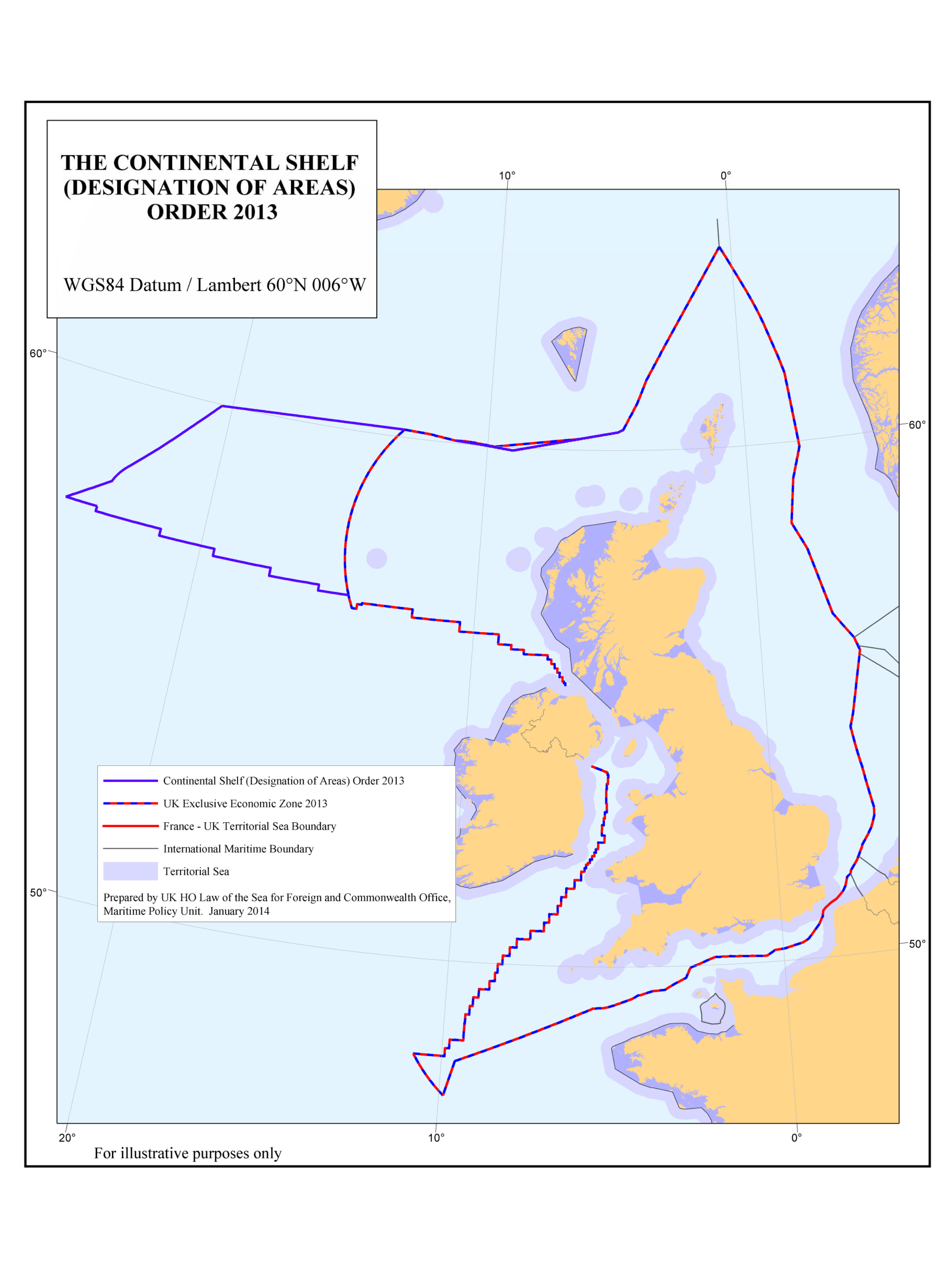
The Exclusive Economic Zone Order 2013 (SI 2013/3161) is an order in Council of the Government of the United Kingdom, which defines the boundaries of the exclusive economic zone of the United Kingdom.
The Order asserts a territorial sea of up to 200 nautical miles away from the coast of Great Britain and from the coast of Northern Ireland.[5]
Before the Order, the UK managed a de facto EEZ: the combination of the renewable energy zone, the marine pollution prevention zone and marine research. The UK negotiated individual borders of the EEZ with specific countries, bilaterally. This was standardised and rationalised by the Order through explicit boundaries, uniform across all purposes.
The Order implements the United Nations Convention on the Law of the Sea(UNCLOS).[6]
The Order is made under the Marine and Coastal Access Act 2009.
The boundaries defined in the Order has been used to analyse maritime and coastal energy projections, varying from renewable energy, blue hydrogen and petroleum.[7] [8] The boundaries defined in the Order have been used to analyse disruption at UK ports.[9]
In 2014, the Foreign and Commonwealth Office published a map showing the differences between the boundaries described by the Exclusive Economic Zone Order 2013 and the boundaries described by the Continental Shelf (Designation of Areas) Order 2013.[10]