Al-Manara, Palestine Explained
| Al-Menara |
| Native Name: | المنارة |
| Native Name Lang: | ar |
| Settlement Type: | Village |
| Etymology: | the light-house[1] |
| Pushpin Map: | Mandatory Palestine |
| Pushpin Mapsize: | 200 |
| Coordinates: | 32.7547°N 35.5422°W |
| Grid Name: | Palestine grid |
| Grid Position: | 201/240 |
| Subdivision Type: | Geopolitical entity |
| Subdivision Name: | Mandatory Palestine |
| Subdivision Type1: | Subdistrict |
| Subdivision Name1: | Tiberias |
| Established Title1: | Date of depopulation |
| Established Date1: | early March, 1948[2] |
| Established Title2: | Repopulated dates |
| Unit Pref: | dunam |
| Area Total Dunam: | 4,185 |
| Population As Of: | 1945 |
| Population Total: | 490[3] [4] |
| Blank Name Sec1: | Cause(s) of depopulation |
| Blank Info Sec1: | Military assault by Yishuv forces |
Al-Manara (ar|المنارة) was a Palestinian Arab village in the Tiberias Subdistrict. It was depopulated during the 1947–1948 Civil War in Mandatory Palestine on March 1, 1948, by Jewish troops. It was located 5 km south of Tiberias.
History
Al-Manara contains Khirbat al-Manara and Khirbat Sarjuna. Crusaders referred to al-Manara as Menan.
The site is identified with Kefar Menori, a village mentioned in the Tosefta.[5]
In 1881, the PEF's Survey of Western Palestine noted at el Menarah: "Ruined Arab houses, all basalt; no cisterns".[6]
British Mandate era
In the 1922 census of Palestine, conducted by the British Mandate authorities, Manara had a population of 122; 121 Muslims and 1 Jew,[7] increasing in the 1931 census to 214 Muslims, in 33 houses.[8]
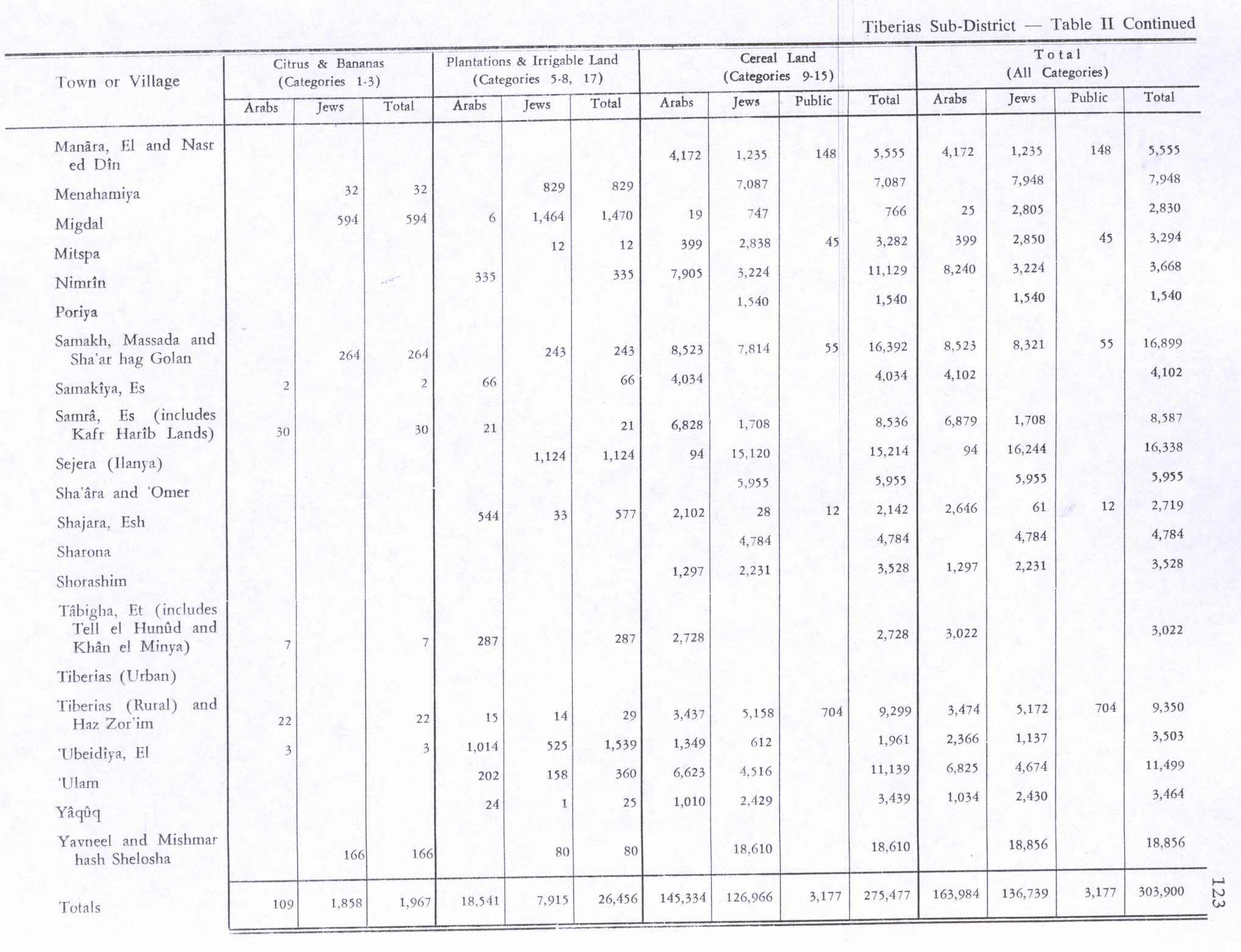
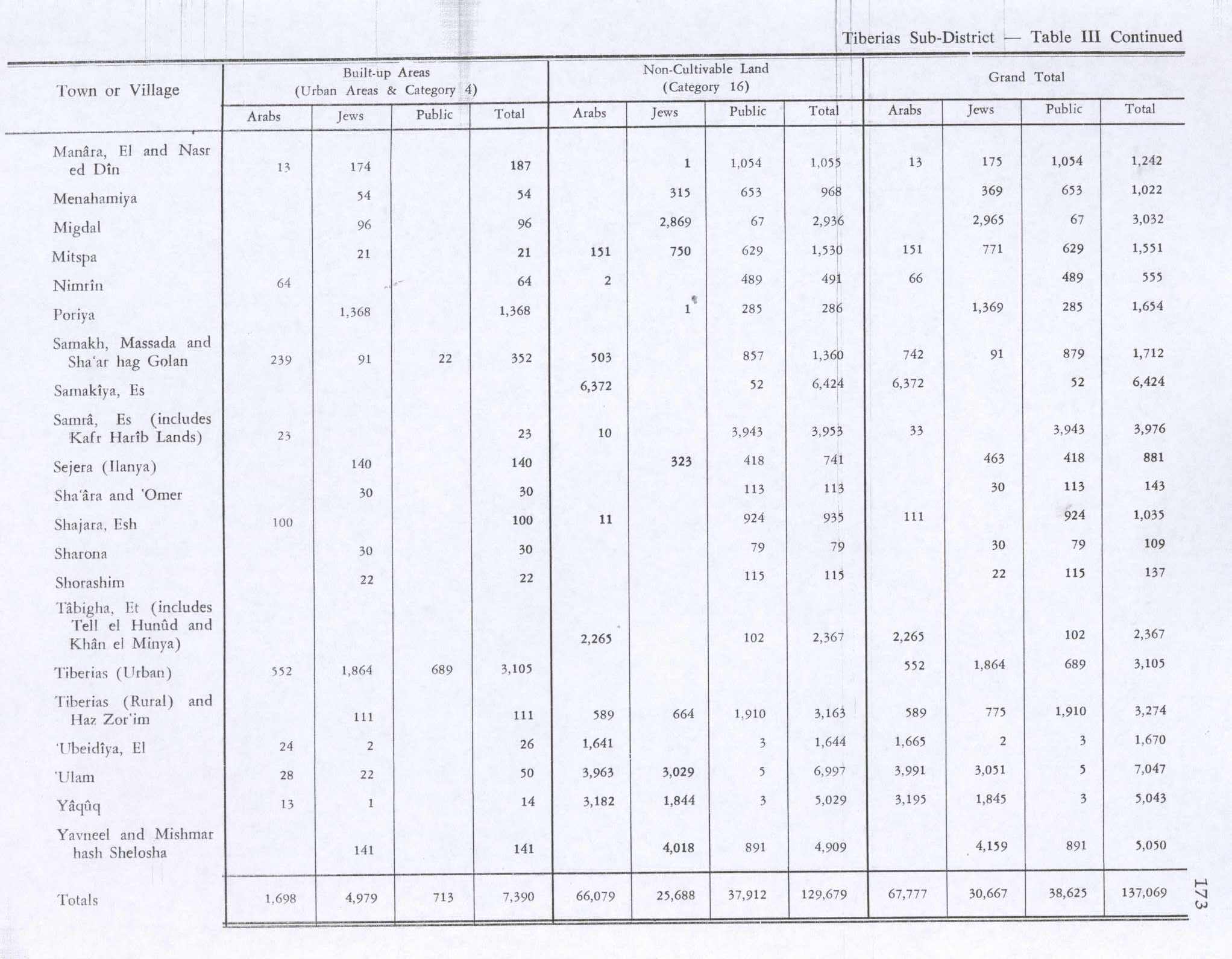
In the 1944/1945 statistics it had total population of 490 Muslims,[3] and together with the people of Nasir ad-Din they had 4,185 dunams of land.[4] Of this, 4,172 dunams of land were used for cereals,[9] while 13 dunams were classified as built-up (urban) area.[10]
1948, aftermath
Al-Manara was depopulated in early March, 1948.[2]
There are no Israeli settlement on village land, the closest is Poria Illit, located to the south of the site.[11] In 1992 the village site was described: "The site has been levelled and is strewn with pieces of black stone. At its northern edge are walls of dark stone, with doum palm trees growing in their midst. At the site, a sign (in Arabic, Hebrew, and English) reads: This is a historical site, please protect it."[11]
Bibliography
- Book: Barron, J. B. . Palestine: Report and General Abstracts of the Census of 1922 . Government of Palestine . 1923.
- Book: Conder. C.R.. Claude Reignier Conder. Kitchener. H.H.. Herbert Kitchener, 1st Earl Kitchener. 1881. The Survey of Western Palestine: Memoirs of the Topography, Orography, Hydrography, and Archaeology. London. Committee of the Palestine Exploration Fund. 1.
- Book: Village Statistics, April, 1945 . Department of Statistics. 1945. Government of Palestine.
- Book: Hadawi, S.. Village Statistics of 1945: A Classification of Land and Area ownership in Palestine. Sami Hadawi. 1970. Palestine Liberation Organization Research Center. 2009-08-18. https://web.archive.org/web/20181208215837/http://www.palestineremembered.com/Articles/General-2/Story3150.html. 2018-12-08. dead.
- Book: Khalidi, W.. All That Remains:The Palestinian Villages Occupied and Depopulated by Israel in 1948. Walid Khalidi. 1992. Washington D.C.. Institute for Palestine Studies. 0-88728-224-5.
- Book: Mills, E. . Census of Palestine 1931. Population of Villages, Towns and Administrative Areas . Government of Palestine . Jerusalem . 1932.
- Book: Morris, B.. The Birth of the Palestinian Refugee Problem Revisited. Benny Morris . 2004 . 978-0-521-00967-6 . Cambridge University Press.
- Book: Palmer, E.H.. Edward Henry Palmer. 1881. The Survey of Western Palestine: Arabic and English Name Lists Collected During the Survey by Lieutenants Conder and Kitchener, R. E. Transliterated and Explained by E.H. Palmer. Committee of the Palestine Exploration Fund.
External links
Notes and References
- Palmer, 1881, p. 131
- Morris, 2004, p. xvii, village #99. Also gives cause of depopulation
- Department of Statistics, 1945, p. 12
- Government of Palestine, Department of Statistics. Village Statistics, April, 1945. Quoted in Hadawi, 1970, p. 72
- Avi-Yonah . Michael . 1976 . Gazetteer of Roman Palestine . Qedem . 5 . 72 . 0333-5844.
- Conder and Kitchener, 1881, SWP I, p. 413
- Barron, 1923, Table XI, Sub-district of Tiberias, p. 40
- Mills, 1932, p. 83
- Government of Palestine, Department of Statistics. Village Statistics, April, 1945. Quoted in Hadawi, 1970, p. 123
- Government of Palestine, Department of Statistics. Village Statistics, April, 1945. Quoted in Hadawi, 1970, p. 173
- Khalidi, 1992, p. 531
